

sbNavi app for iPhone and iPad
Developer: SBOING
First release : 09 Nov 2013
App size: 16.28 Mb
• Uses custom maps, based on the free and open maps of OpenStreetMap (OSM, www.openstreetmap.org).
• Adaptive and self-improving, due to its collaborative and crowd-sourcing nature,
• By utilizing historical traffic data, it leads to more accurate routing decisions, compared to existing commercial PNAs,
which are based on static traffic information (i.e. the speed limit of each road),
• Distinguishes and provides better time estimates, depending on the type of vehicle (e.g., pedestrian, fast / slow
motorcycle, fast / slow car, truck, bus, taxi), weather and corresponding road conditions (sun, rain, snow, etc.), time-of-day,
day-of-the-week, holiday and season-of-year,
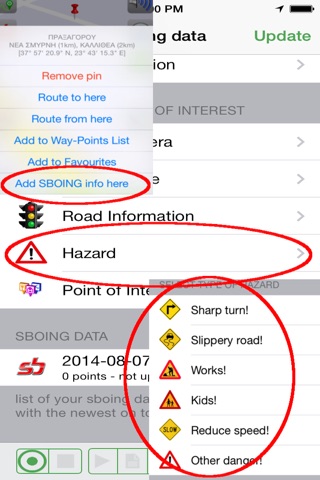
• It has an inherent, independent mechanism: a) to produce new maps (for uncharted areas), and b) to self-update existing maps
(crowd sourcing support by entering user input about road hazards, police blocks, traffic lights, traffic signs, POIs, favorites,
road network changes, etc.)
• High usability with most of its functionality achieved with 1-2 user clicks
• Multiple, user-defined views using user-defined macros (a unique feature)
• High user-configurability (configuration menu, map style/colors, POI layers, favorites categories, vehicle choice, day/night
mode, etc.)
• Route simulation mode
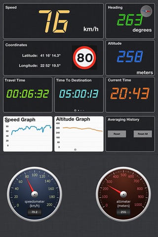
• Dashboard with two digital screens and one with analog gauges
• 2D and 3D map viewing with pan, zoom, and rotate functionality, with continuous varying 3D viewing angle (tilt)
• "Lock on drivers view" functionality
• User routes can be recorded and recorded routes can be managed, securely up-loaded to SBOING, sent by email and replayed (on
the smartphone, on a PC, or via Google Earth)
• Searching: a) by free text search, b) in Favorites, c) in POIs, d) by coordinates, e) by proximity
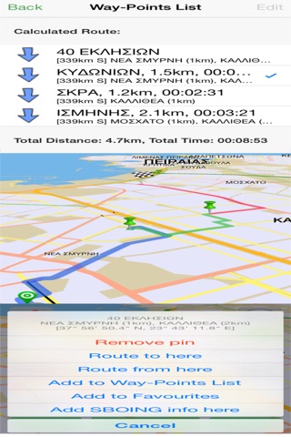
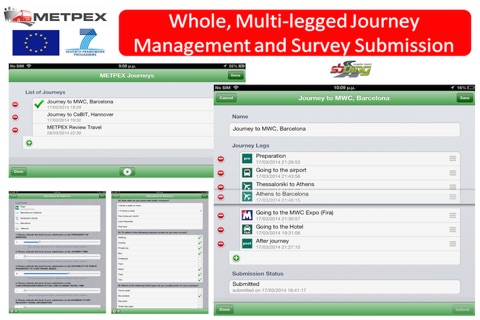
• Easy definition of multi-waypoint lists
• Multi-waypoint (multi-legged) routing
• Multi-lingual support for text and voice guidance
• Able to accommodate the maps of the entire planet in a single memory card
• Adaptive and compatible with a plethora of PNAs and smartphones,
• Uses strong security (strong encryption) in all data uploads carried out by the user, thus ensuring the confidentiality of
its private information.
• In-app version upgrades and support for promotion upgrades.
Disclaimer: Continued use of GPS running in the background can dramatically decrease battery life.